Balham (BAL)

Balham is a station on the Brighton Main Line in the South London borough of Wandsworth. A London Underground Northern Line station of the same name is adjacent to it.

Information
Type: National Rail
(Brighton Main Line)
Station code: BAL
Opened: 1856
Platforms: 4
A station called Balham Hill was opened by the West End of London & Crystal Palace Railway in 1856 which became part of the London, Brighton & South Coast Railway (LB&SCR) in 1859.  The LB&SCR moved the station a short distance to it's current location in 1863 and renamed Balham.

However the station was renamed again to Balham & Upper Tooting in 1927 before finally being changed back to Balham again in 1969. The station was electrified as part of the LB&SCR's 6600v AC overhead line "Elevated Electric" system in 1911 [1] though due to interruption caused by the First World War all of the lines through the station were not completed until 1925. However in the same year Southern Railway, who now operated the LB&SCR lines decided to standardise on DC third rail, Balham was converted in 1929.

Balham is built on an embankment with access between the platforms via an underpass. Although there are four platforms only two are usually used. The station is managed by Southern who operate all services though the station to destinations including London Victoria, London Bridge, Epsom, Sutton and Milton Keynes Central.
Southern 455 825 departs

One island is in use


LB&SCR overhead lines at Balham Junction in 1911, public domain image [2]

Southern 377 128 arrives

[1] "Single phase electrification of the London, Brighton & South Coast Railway", Electric Railway Journal (Jan-June 1911) Vol. XXXVII No. 18, p. 784
[2] Ibid. p. 786

Stroud (STD)

Stroud serves the market town of the same name in Gloucestershire. It is on the Swindon-Cheltenham Line.

Information
Type: National Rail
(Swindon-Cheltenham Line)
Station code: STD
Opened: 1845
Platforms: 2
The station was opened in 1845 by the Cheltenham & Great Western Union Railway. The station was designed by Isambard Kingdom Brunel and later became part of the Great Western Railway. The station was to GWR's broad gauge until being converted to standard gauge in 1872.

As Stroud had another station, Stroud Wallbridge, opened by the Midland Railway the GWR station was known as Stroud Great Western and later Stroud Central. After the closure of the other station in the late 1940s the name simply became Stroud.

Stroud retains it's original station buildings with a footbridge between the two platforms and a ticket office.
Station frontage, rather less imposing than some other Brunel designs

Both platforms have canopies 
Looking down the line to Swindon, former bay siding on the left

Station building on the Cheltenham platform

The station is managed by the GWR's modern namesake

GWR 43 154 arrives with a Gloucester bound HST

Angel (ZAN)

Angel is a stop on the Bank branch of the Northern Line between Kings Cross St Pancras and Old Street.

Information
Type: Transport for London
(Northern Line)
Station code: ZAN
Opened: 1901
Platforms: 2
The station was opened by the City & South London Railway in 1901 and served as the line's Northern terminus until 1907. Originally as built Angel had a single narrow island platform for it's two lines like other C&SLR stations.

The station was rebuilt in the 1990s to try and rectify the station's overcrowding problem with a new tunnel excavated and platform for North bound trains. The original tunnel became an extra-wide platform for South bound services. Access to the platforms from the surface was originally via three lifts but during the rebuilding these were replaced by escalators, one of these being the longest on the London Underground and the fourth longest in Europe [1]. The main escalator is sixty metres long and rises twenty-seven metres [2].
South bound tunnel, originally an island platform

Another view of the South bound platform

Heading down the escalator

[1] Paul Moss, London Underground (Haynes, 2014) p. 158
[2] Jason Cross, London Underground Guide 2017 (Train Crazy, 2017) p. 99

The Hawthorns (THW)

The Hawthorns is a railway / light rail interchange in West Bromwich. It is adjacent to West Bromwich Albion's football ground and shares the same name.

Information
Type: National Rail
(Jewellery Lines) &
TfWM Midland Metro
Station code: THW
Opened: 1995
Platforms: 2 (+2 Metro)
The station was opened in 1995 on the site of the football-only Hawthorns Halt which was opened by the Great Western Railway in 1931 and stayed open until 1968 though only served football specials.

The Hawthorns was opened as part of the Jewellery Line which restored services to Birmingham Snow Hill unlike the earlier station it is open every day the railway is open and not just on match days.

In 1999 the Midland Metro also opened stops next to the railway station. Access between the platforms is via an over bridge to the ticket hall and station entrances.
LM 172 337 stops on a Stourbridge bound service

Access bridge between all platforms, here we are on the Metro platform, a railway platform is to the right

Railway platforms view

Two Midlands Metro trams

LM 172 345 departs heading for Birmingham

Canary Wharf (ZCW)

Canary Wharf Docklands Light Railway station and the nearby Jubilee Line tube station have been built to serve the office and shopping complex built as part of the Docklands regeneration in the 1980s.

Information
Type: Transport for London
(Jubilee Line &
Docklands Light Railway)
Station code: ZCW
Opened: (DLR) 1991
(Jubilee) 1998
Platforms: (DLR) 6
(Jubilee) 2
The DLR station was first, it was part of the original plans for the Docklands Light Railway though not opened until 1991 [1]. Initial plans for the station were fairly modest but the size of the Canary Wharf development and expected passenger numbers saw the plans change to include six platforms for three tracks. The station is very close to Heron Quays and West India Quay DLR stations.

The Jubilee Line was bought to Canary Wharf to supplement the DLR line which was seen as being inadequate for expected custom. The new station, which is separate from the DLR station though pretty close (though Heron Quays is actually slightly closer), was the centrepiece of the huge Jubilee Line Extension project [2]. The station was built in a former drained dock of the Thames and is a huge pit twenty four metres deep and two hundred and eighty metres long by thirty two metres wide [3]. Designed by Sir Norman Foster Canary Wharf tube station has a dramatic modern design and has been voted the most loved tube station by the general public. The Jubilee Line platforms have platform edges doors like the other underground stations on the JLE [4].

Canary Wharf tube station is the second busiest tube station outside of central London with over fifty four million entrances and exits a year. The DLR station is somewhat quieter having only over nineteen million entrances and exits a year! Both stations will be joined by Canary Wharf railway station in late 2018, being built as part of the Crossrail / Elizabeth Line project.
DLR #155 at Canary Wharf, each line has double platforms

Street entrance to the tube station, there are two either end of the station

Canary Wharf tube station concourse, notice the columns and light from the street entrance

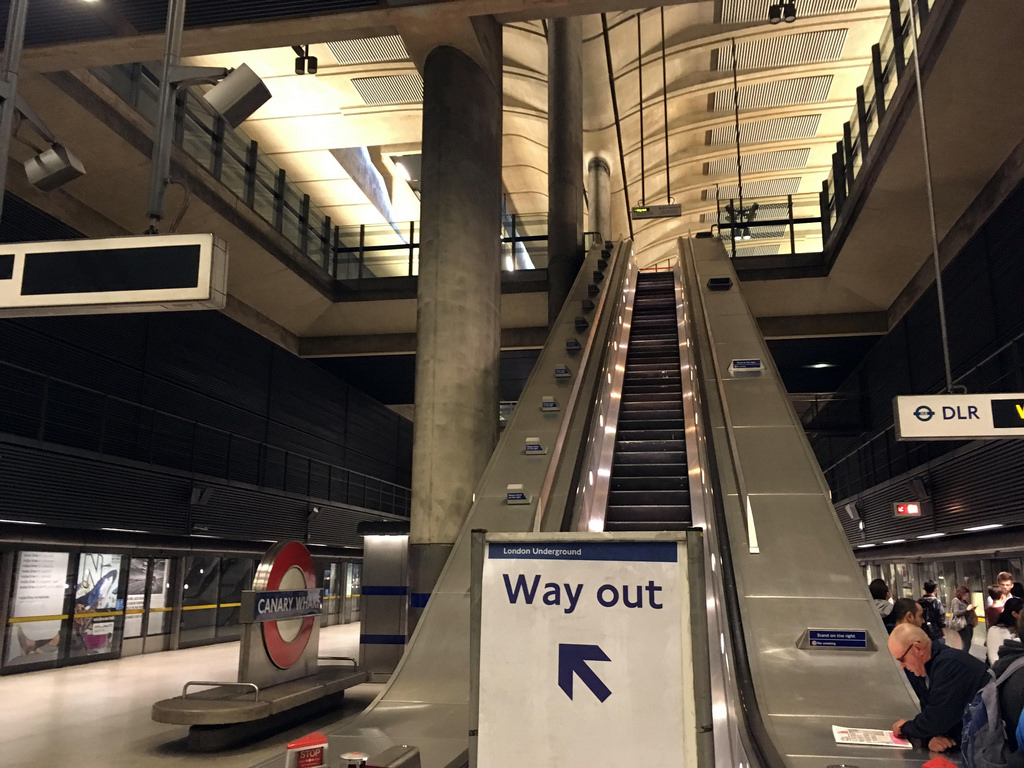
Platform level, the Jubilee Line platforms have platform edge doors
A DLR train crosses in front of the tube station, Canary Wharf DLR is to the left, Heron Quays the right

Jubilee platform station sign and seat

[1] Stephen Jolly & Bob Bayman, Docklands Light Railway Official Handbook (Capital Transport, 1986) p. 24
[2] Paul Moss, London Underground (Haynes, 2014) p. 165
[3] Mike Horne, The Jubilee Line (Capital Transport, 2000) p. 71
[4] Jason Cross, London Underground Guide 2017 (Train Crazy, 2017) p. 108

Aston (AST)

Aston station lies on the junction of the Cross-City & Chase Lines in Aston on the Lichfield Road. Although the station signs advise fans to alight here it isn't the nearest station to Aston Villa's ground, that is Witton.

Information
Type: National Rail
(Cross-City & Chase Lines)
Station code: AST
Opened: 1837
Platforms: 2
The station first opened in 1837 as part of the Grand Junction Railway. Like a number of stations in inner Birmingham it is built on an embankment with access to the platforms via stairways and lifts. The station has a ticket office and shelters on both platforms. Interchange between the platforms is via street level.

Platform structures are nowadays pretty basic (though adequate). The station used to have much more elaborate structures on both platforms with canopies though these are now long gone. The station was rebuilt in 1993 [1]. A goods depot and a locomotive depot also used to be near to the station but these are both now long gone.

As well as services to Birmingham New Street there are also West Midlands Railway services to Wolverhampton, Walsall, Lichfield, Sutton Coldfield, Rugeley, Redditch and Longbridge from the station.
LM 323 211 departs with a North bound service

Station sign

Platform shelter

As dusk falls a LM 323 departs for the city

[1] Vic Mitchell, North of Birmingham (Middleton Press, 2014) fig. 81

Woburn Sands (WOB)

Woburn Sands serves a village in Buckinghamshire near to Milton Keynes on the Bletchley to Bedford Marston Vale Line. Woburn Sands is between Bow Brickhill and Aspley Guise.

Information
Type: National Rail
(Marston Vale Line)
Station code: WOB
Opened: 1846
Platforms: 2
The station was opened by the Bedford Railway in 1846 as Woburn, the name changing to Woburn Sands in 1860. The original station building, a Grade II listed Gothic Revival cottage, survives but is now a coffee shop.

The station had a goods yard with wagon turntables and a coal yard and siding serving a gas works. As with many stations of its size Woburn Sands was run down in the 1960s. The goods yard was closed and the station became an unmanned halt in 1967. With a level crossing at one end of the station Woburn Sands did retain a signalbox until 2004.


Access between the platforms is via the level crossing / road. The station is a basic halt with a couple of shelters and public information screens.
WMR 150 107 departs heading for Bedford

View down the platform, shelter on the left

Sign made by local school children

WMR 153 334 about to go through the level crossing
Looking towards Bletchley

WMR 153 334 on a Bletchley service

South Kenton (SOK)

South Kenton is a station on the Watford DC Line in North West London and also a stop on the London Underground Bakerloo Line.

Information
Type: Transport for London
(London Overground
Watford DC Line &
Bakerloo Line)
Station code: SOK
Opened: 1933
Platforms: 2
The station was opened by the LMS in 1933 adjacent to the West Coast Main Line but only served by the Watford DC Lines [1]. The station was built with Art Deco features including a "streamlined" waiting room.

The Bakerloo Line also stops at South Kenton though services ended in 1982 before being restored two years later. Due to the platform being built for standard size stock there is a bit of a step down (or step up) for passengers on Bakerloo Line tube trains. Transport for London took over management of the station in 2007 with the advent of London Overground.

The station has a single island platform accessed via a pedestrian tunnel (originally the platform was reached via a footbridge). The ticket office for the station is on the platform. Due to the lack of available space the station does not have ticket barriers, being one of the few London Underground stations without them.
London Euston bound LO 378 218 stops at the station

Art Deco waiting room

Viewed from the platform, Southern 377 705 passes on the WCML

A Northbound Bakerloo Line 72ts train waits to depart

Bakerloo Line trains require a step down from the platform

Although a third & fourth rail station overhead line catenary masts are based on the platform

[1] Jason Cross, London Underground Guide 2017 (Train Crazy, 2017) p. 126

Huyton (HUY)

Huyton is a station on Liverpool-Wigan and Liverpool-Manchester Lines and one of the oldest railway stations in the world.

Information
Type: National Rail
(Liverpool-Wigan Line)
Station code: HUY
Opened: 1830
Platforms: 4
The station was opened in 1830 as Huyton Lane Gate on George Stephenson's pioneering Liverpool and Manchester Railway, the first entirely steam powered railway. The name was changed first to Huyton Lane in 1839 and finally to just Huyton in 1852.

The oldest parts of the current station, including the ticket office, date from when it was owned by the London & North Western Railway (who took over the Liverpool & Manchester Railway in 1846). In the 1970s Huyton was cut back with two of the platforms taken out of use.

However both have been bought back into use in recent years as part of a station modernisation and the electrification of the Liverpool to Manchester route.
Northern 319 371 pauses at Huyton 
A Rail Head Treatment Train passes through

Station sign

Main station building on the right

Northern 319 371 heads off bound for Liverpool Lime Street


Shenstone (SEN)

Shenstone is a stop on the Cross-City Line between Blake Street (and the West Midlands-Staffordshire boundary) and Lichfield City.

Information
Type: National Rail
(Cross-City Line)
Station code: SEN
Opened: 1884
Platforms: 2
The station was opened by the London & North Western Railway in 1884 when it extended it's line from Sutton Coldfield to Lichfield. The station originally had a goods yards and cattle pens though these were closed in the 1960s [1]. A signal box just South of the station closed in 1970.

The main station building (which includes the ticket office) remains intact with it's GWR style stanchion-less canopy. A similar but smaller structure on the other platform has now been replaced by the ubiquitous bus shelter. The line was electrified in 1993. Shenstone is served by trains every thirty minutes in each direction.
WMR 323 222 departs with a Lichfield bound service

Shenstone station building

A view of the station from the road bridge

Access between the two platforms is via this road bridge

Station building

WMR 323 222 returning to Birmingham (and beyond)

[1] Vic Mitchell, North of Birmingham (Middleton Press, 2014) map. XXXII