Aldwych is probably the most famous of the various disused, but still extant, stations on the London Underground. The station was originally called Strand after the street the station is located on and was the terminus of a short branch of the Piccadilly Line from Holborn.
Information
Type:
London Underground (Piccadilly Line)
Opened:
1907
Closed:
1994
Platforms:
2
Strand, which was renamed Aldwych in 1915 (the Strand name was given to the nearby Northern Line station at Charing Cross), always struggled for custom. Originally it had 2 platforms but one platform was closed as early as 1917 and later used to store paintings from the National Gallery [1] during the zeppelin bombing raids late in World War 1.
During World War 2 the station was fully closed and used as an air raid shelter. Low passenger numbers continued to dog the station and it was considered for closure many times with various schemes for extensions coming to nothing. The station was reprieved over and over again but in the early 1990s the original lifts needed replacement and the cost was uneconomic considering less than 500 people typically used the station every day so Aldwych closed for good in 1994 [2].
Or did it? Infact the station had remained intact and continues to be used for filming and training purposes as well as regular tours. Aldwych has a number of historic items of interest including the surviving original rail on platform 1 which is the oldest surviving rail on the Underground dating from the early 20th century. Much of the interior of the station has been unchanged for decades and can give an idea of how the Underground looked in the mid-20th century though some features are "faux" vintage and are additions to help with filming the various films and TV shows that have used the station. The station was also used to test designs for tiling and paint schemes from the 1920s onwards [3].
The station and branch line currently remains connected to the rest of the Underground and a working train of 1972 Tube Stock is stabled at the station. However planned improvement works to Holborn may force the severing of the link to the Aldwych branch.
On the surface
Entrance to the lifts and the convenience
A lot of steps down (and up!)
Platform 1 which closed in 1917, the rails here are the oldest surviving on the underground
A train of 1972 Tube Stock on platform 2
Passageway
[1] Antony Badsey-Ellis & Mike Horne, The Aldwych Branch (Capital Transport, 2009) p. 41 [2] Ben Pedroche, Do Not Alight Here (Capital History, 2011) p.14 [3] Badsey-Ellis & Horne p. 75
Elephant & Castle is a stop on the Bank branch of the Northern Line and also the Southern terminus of the Bakerloo Line. It is next to the National Rail station of the same name.
Information
Type:
Transport for London
(Bakerloo & Northern Lines)
Station code:
ZEL
Opened:
1890
Platforms:
4
The station was first opened by the City & South London Railway in 1890, later to become part of the Northern Line. The station was one of six original stations on the first tube line between Stockwell and King William Street [1].
The Baker Street & Waterloo Railway (later Bakerloo Line) arrived in 1906. The station had a separate surface station building designed by Leslie Green (though there is interchange between the two sets of platforms below ground). Originally the Bakerloo had wanted a subsurface ticket office but this was blocked by the local council [2]. The station is the Bakerloo's Southern terminus, the line running on a short distance after the platforms for stabling. Southern extensions have been planned for the Bakerloo since the 1930s [3] and the current proposals are to extend the line to Lewisham.
The station was used as an air raid shelter in the First World War [4]. The first baby to be born on the underground was at Elephant & Castle in 1924. A major upgrade and rebuild of the station is being planned with a new ticket hall for the Northern and improved escalators and lifts.
A Bakerloo Line train prepares to return North
Bakerloo Line platform
Platform roundel
Northern Line platform
[1] Jason Cross, London Underground Guide 2017 (Train Crazy, 2017) p. 120 [2] Mike Horne, The Bakerloo Line (Capital Transport, 2001) p. 22 [3] Ibid. p. 40 [4] Paul Moss, London Underground (Haynes, 2014) p. 55
Trafalgar Square is no longer on the tube map though still exists as part of Charing Cross tube station and was the first part of the current station to be built [2].
Information
Type:
Transport for London
(Bakerloo Line)
Opened:
1906
Closed:
1979 (merged into Charing Cross)
The station was opened by the Baker Street & Waterloo Railway (later Bakerloo Line) in 1906. The Charing Cross, Euston & Hampstead Railway (later the Northern Line) opened an adjacent but separate station on the Strand called Charing Cross a year later.
Although both stations were owned by the Underground Electric Railways of London company there was no underground interchange, passengers had to travel to the surface to transfer that way. The Northern Line station was renamed Charing Cross (Strand) in 1914 and Strand in 1915 (taking the name of a nearby Piccadilly Line station which was renamed Aldwych). Another Charing Cross station already existed by the way, operated by the District Railway.
As with Regent's Park on the original stretch of the Bakerloo Line it was not possible to construct station buildings on the surface so an underground ticket office was built [3].
The building of new platforms for the Fleet Line (renamed Jubilee Line by the time it opened) in the 1970s gave London Underground the opportunity to finally merge the Northern and Bakerloo stations [4]. The new station was named Charing Cross in 1979 (the District Line Charing Cross was renamed Embankment) and Trafalgar Square ceased to exist as a separate station and on the tube map. Platform signs on the Bakerloo platforms however still say "For Trafalgar Square" under Charing Cross on the LU roundel.
Original platform just before opening note the name on the tiles, public domain image [1]
Trafalgar Square today, now part of Charing Cross
A Bakerloo Line train stands at the former Trafalgar Square station
[1] "Baker Street & Waterloo Railway of London", Street Railway Journal Vol. XXVII No. 14 (April 1906) p. 554 [2] Chris Nix, Charing Cross access all areas (London Transport Museum, 2017) p. 2 [3] Mike Horne, The Bakerloo Line (Capital Transport, 2001) p. 18 [4] Ibid. p. 67
Hemel Hempstead is a stop on the West Coast Main Line in Hertfordshire in between Berkhamstead and Apsley.
Information
Type:
National Rail
(West Coast Main Line)
Station code:
HML
Opened:
1837
Platforms:
4
Hemel Hempstead was opened as Boxmoor in 1837 by the London & Birmingham Railway. It was the Northern terminus of the line from London Euston for a few months until the line was extended to Tring later in the year. The station was built about a mile outside of the town centre due to opposition from land owners.
A later station, called Hemel Hempstead, was built by the Midland Railway in the town centre. To compete with this interloper the original station, then owned by the LNWR, was renamed Boxmoor & Hemel Hempstead in 1912. The name went through a few tweaks in the following decades, becoming Hemel Hempstead & Boxmoor in 1930. The ex-Midland station was closed in 1963 allowing the original station to finally be named Hemel Hempstead!
Hemel Hempstead is served by regular trains between Milton Keynes Central and Tring to London Euston, operated by London Midland who manage the station. Less frequent services from further afield including Birmingham New Street also stop at the station.
Southern services between Milton Keynes Central and East Croydon via the West London Line also stop. Virgin Trains services pass through the station but do not stop. The station has platforms on both the WCML slow and fast lines, the latter are more intensively used. There was once a South facing bay platform but this is now disused. The platforms (and lines) are built on an embankment with access between the platforms being via a subway.
LM 350 254 on a Euston bound service
Hemel Hempstead has gold name signs honouring Olympic success as common with LM managed stations
Platform buildings
Looking down towards London
Southern 377 705 pulls into the station on a South bound service
Darlington is one of the birthplaces of the modern powered railway due to the pioneer Stockton & Darlington Railway which passed through the site now occupied by Darlington station in 1829.
Information
Type:
National Rail
(East Coast Main Line &
Tees Valley Line)
Station code:
DAR
Opened:
1841
Platforms:
4
Darlington, also known as DarlingtonBank Top, was opened as the terminus of the Great North of England Railway in 1841, with the line continuing North to Tyneside in 1844. The original building (intended as "temporary") was replaced after 15 years in 1859 in the North Eastern Railway (who operated the line by then) style. A few years later the Stockton & Darlington and North Eastern Railways merged, Darlington Bank Top took over S&D services from Darlington North Road.
The current station buildings date from another rebuilding which opened in 1887 and included a three span roof and new interchange lines. The station became a busy interchange station due to its links to the likes of Richmond, Bishop Auckland and Saltburn.
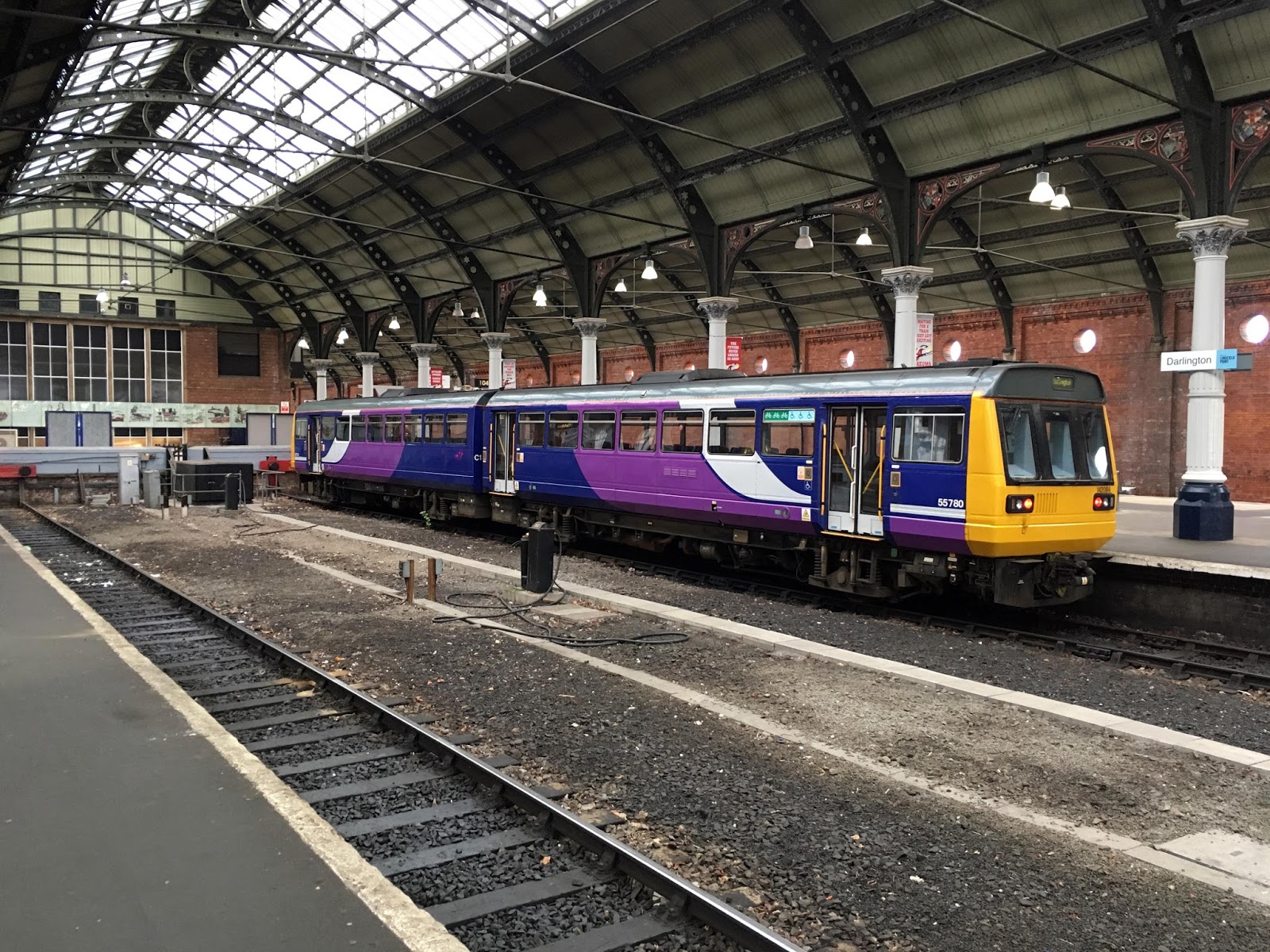
Darlington is a stop on the East Coast Main Line served by Virgin East Coast and also hosts services by Northern, Trans Pennine Express and Cross Country. The station has two through roads and two South facing bay platforms. There were once also bays to the North but these closed in the 1960s.
South facing bay platforms, usually occupied by Pacers
View of the roofs from down the platform
Virgin 91 121 propels a North bound ECML express through the station
Leytonstone in East London is a stop on London Underground's Central Line however for its first 91 years of existence it was served by main line steam trains.
Information
Type:
Transport for London
(Central Line)
Station code:
ZLE
Opened:
1856
Platforms:
3
The station was first opened in 1856 by the Eastern Counties Railway and later was operated by the Great Eastern Railway and LNER, not becoming part of the London Underground until 1947 [1] when it became part of the Central Line. Leystonstone is at the junction of the two Central Line Eastern branches: direct to Woodford and Epping and the Hainault Loop[2].
The station was extensively rebuilt due to a new road underpass being built to eliminate a level crossing [3], the work started just before the Second World War but was stopped in 1940 due to wartime priorities, the station was hit during a bombing raid in 1944 which also delayed matters. The work was finally completed after the end of the war and Leytonstone became a tube station in 1947, acting as the Central Line's Eastern terminus for a few months until the opening of the stretch from Woodford to Newbury Park.
Leytonstone has 3 platforms, the centre platforms usually being used for West bound services but also terminating East bound trains.
92ts 91013 leads a train heading back to London
View down the platform
An West bound Central Line train prepares to depart
[1] Jason Cross, London Underground Guide 2017 (Train Crazy, 2017) p. 139 [2] Robert Griffiths, The Central Line (Past & Present, 2007) p. 28 [3] J. Graeme Bruce & Desmond F. Croome, The Twopenny Tube (Capital Transport, 1996) p. 50
Stratford-upon-Avon was once a stop on the Birmingham Snow Hill to Cheltenham line but since 1976 has been a terminus of both the North Warwickshire Line (known these days as the Shakespeare Line) and the Leamington-Stratford Line.
Information
Type:
National Rail
(Shakespeare Line &
Leamington - Stratford Line)
Station code:
SAV
Opened:
1865
Platforms:
3
The station was an amalgamation of two earlier adjacent stations opened on lines by the Oxford, Worcester & Wolverhampton Railway from Honeybourne and the Stratford Railway from Hatton. A combined station was opened in 1863 [1]. The current station opened in 1865 North of the original amalgamated station [2] and later became part of the Great Western Railway. The main building and footbridge of the station was completed in 1891, both remain in good condition.
The main line from Birmingham to Cheltenham was opened in 1908 and Stratford-upon-Avon was expanded, a third platform added. All three platforms remain open though platform 3 is only used occasionally these days. A track cross over has been retained South of platforms 1 and 2 for use by locomotives (often steam) on excursions to run around the train.
Passenger services South of Stratford which began in 1911 ended in 1968 though the line remained open for freight until 1976. The station was improved in 2015 with a second footbridge with lifts added. Other improvements to the station are planned.
Chiltern 165 008 underneath the original footbridge
Steps up the new footbridge
Station entrance
Platform view, both bridges can be seen
Both London Midland and Chiltern Railways serve the station
[1] Colin G. Maggs, The Branch Lines of Warwickshire (Amberley, 2011) p. 122 [2] Vic Mitchell & Keith Smith, Stratford-upon-Avon to Birmingham (Moor Street) (Middleton Press, 2006) p. IX